Category Archives: Weather

Mississippi Tornadoes of March 24, 2023

A quick and very unorganized collection of data & photos from the devastating tornadoes that struck after dark on March 24. As of 9 a.m. on the 25th, at least 23 are dead.

Large-scale environment

Even in model runs from Thursday night (24 hours before the event), there was high confidence of sufficient CAPE and shear for organized storms in west and southwest MS — with the favorable environment expected to translate eastward as the night went on.

With considerable veering in the typical tornado-bearing layer.

Weather balloon launched in Oak Grove, MS, while the first non-tornadic supercell was moving through central MS, but before the tornadic storms developed:

Thanks to the staff at WFO-Jackson, we have data from a very rare 3Z sounding. With an EHI greater than 3, this environment lands squarely in a parameter space for large, damaging, deadly tornadoes. The second image below is a set of F2-F5 tornado cases collected by Jon Davies.

From http://davieswx.blogspot.com/2021/04/march-25-2021-deadly-tornado-outbreak.html

Storm structure

At Rolling Fork, the radar presentation of strong rotation and debris lofted high into the atmosphere suggested a violent tornado. We’ll wait for the damage survey to confirm:

Matt saved this velocity data showing the development of the third tornado (Amory / Smithville):

(Added…) And Sam’s statistical analysis of the Amory storm’s radar/debris signature:

A view from infrared radar of the first tornadic storm, and also the supercell that had already developed and moved north of Jackson (no tornado there, though).

Damage

Nighttime damage photos usually don’t give you a sense for how bad the damage really is, but they are our first quick look:

Photos the next morning provide the real clarity:

And a drone view, from the morning after:

Andover, Kansas Tornado – 29 April

These photographs and videos are not in time order (right now), but are just ones that I wanted to quickly save before they scrolled past my feed.

Photograph of lots of damage from Andover:

Quite photogenic at this point:

[I deleted two embeds that were here because the driver went the wrong way around a roundabout, with a car approaching, was filming while driving, and then ran a red light. I will not share videos from people like that.]

Another nice video of the funnel:

A close-up video that shows destruction of individual houses:

I think this was earlier in the lifetime of the tornado, before it moved into the populated parts of Andover:

And as the tornado began moving into populated areas. Some profanity in this one:

I thought this one was a time lapse at first, but no!

Chicago Suburbs Tornado

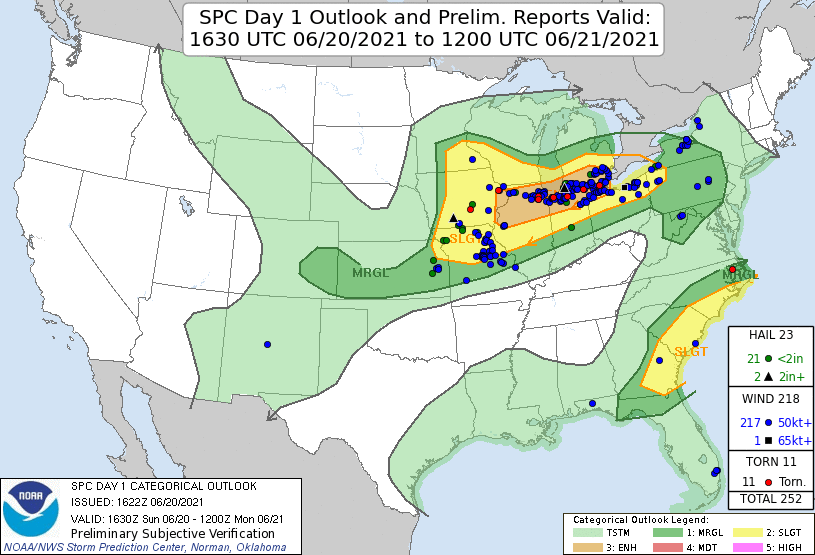
A strong tornado struck areas west of Chicago on Sunday night, June 20. A quick set of maps and data to remind myself about the event & what to talk about when it comes up in class.

Where

Environment

The proximity sounding from KILX, with high CAPE, low LCL/LFC, and a very large 0-2 km hodograph but unidirectional winds above. All the convection-permitting models showed that this parameter space extended into N IL, to the convection itself (0-1 km SRH shown, but CAPE, other shear parameters, and therefore all the composite parameters demonstrated the same).

The tornado occurred smack in the middle of the “enhanced” risk region. (As of the time this post was written, the tornado report was not yet included in the SPC database — but it should appear eventually.)

Storm

A very obvious debris signature just before 11:30 p.m. CDT. At first, I thought it odd that the velocity couplet wasn’t gate-to-gate — as it usually appears — but at this distance the radar is sampling at only 700-800 feet off the ground. That’s the tornado itself.

https://twitter.com/NOAABrauer/status/1406830551571603457

A combination of power flashes, lightning, and maybe a beacon on top of a distant tower:

https://twitter.com/ddofinternet/status/1406830804261556230

The storm lofted debris to nearly 20,000 feet (at least one image showed possible lofting a few thousand feed higher). Based on radar climatology, the strength of the rotational signature and height of the likely debris indicated a high probability of EF2 or EF3 damage.

Damage

Earlier (different storm)

Bloomington, IN Flood — Damage

A major flood event occurred in downtown Bloomington on June 18 and 19. Here are some photos and videos of the ongoing flooding, mostly near the Kirkwood Avenue and Campus Crescent area (I think that’s the correct name). I’ve also included a series of damage photos and the Indianapolis Star story from the morning of the 19th.

https://twitter.com/MikeWoodsonFake/status/1406089082644611072

Added on 6 July, another set of great screenshots depicting the Kirkwood flooding as it happened:

Views from Elsewhere

Not part of the Bloomington flooding, but pretty pictures from elsewhere around Indiana on this day:

https://twitter.com/captainomorgano/status/1406065880774189056

Bloomington, IN Flood — Meteorology

A major flood event occurred in downtown Bloomington on June 18 and 19. Here’s an overview of just a couple pieces of the relevant meteorology.

Environment

A warm front lifted north through Indiana during the day, bringing dewpoints in excess of 70 F, and surface temperatures almost 10 F warmer than normal, even for June. The front would later stall and serve as the lifting mechanism for multiple rounds of storms.

Surface map from WPC, 19 UTC 18 June 2021

Deep atmospheric moisture, with precipitable water values that were 1-2 standard deviations above normal for June in Illinois and Indiana

The combination of extreme instability (see CAPE values in excess of 4000 J/kg, below) and a wind shear profile with only modest curvature (see the surface, 850 mb, and 500 mb wind “crossover” below) were favorable for multicell storms in the form of an MCS / squall line.

Radar loop to be inserted here later, but for now, here’s the 10 p.m. EDT radar image. These storms developed and moved almost parallel to Indiana Highway 46, between Terre Haute and Bloomington, for about three hours.

Precipitation Totals

From the CoCoRaHS network, consistent reports of 5 inches of rain, with one report in Ellettsville of 7.42 inches. At the Bloomington / Monroe County Airport, the report was 3.04 inches (I think), and the IU climate station reported 4.95 inches.

Climatology

https://twitter.com/indianaclimate/status/1406257208208375813

A smattering of damage photos in the next post.

Jonesboro, AR Tornado (28 March)

Some early images from today’s tornado in Jonesboro, Arkansas.

The growing tornado, up close:

https://twitter.com/joeysulipeck/status/1244042536857014274

From rain free base to tornado, via an Arkansas DOT camera:

https://twitter.com/WeatherNation/status/1244023724984037384

The tornado, from way too close:

Radar data have some correlation to tornado wind speeds:

Kevin realized that today’s synoptic pattern resembled that of the 1968 Jonesboro tornado:

https://twitter.com/wxkev/status/1244051931481264129

In the Plains, the dryline often serves as a focal point for convective initiation. It is quite rare to see a dryline propagate into Arkansas and Missouri:

Damage at the airport, where the tornado passed very close by:

https://twitter.com/wxkev/status/1244052449662341120

Damage at the mall:

https://twitter.com/Kelmarie2003/status/1244039829215739905

Nashville Tornado — 3 March

Before sunrise on 3 March, a tornado moved through north and east Nashville, killing at least 9 (as of 9 a.m.). Here are some of the media related to the storm.

https://twitter.com/LuluLady/status/1234757534319357952

This mid-rise building appears to have lost a portion of its roof:

Brick walls go down easily in tornadic winds:

Photo of the tornado:

Radar data from the storm, showing the “debris ball” and tight velocity couplet:

Skew-T proximity sounding for the event from UAH:

Another one, from the NAM (00 UTC run, 6 h forecast):

Regional radar and satellite data show that the storm’s inflow was virtually unaffected by any nearby convection:

Watch out for optical illusions — this photo was shared by multiple members of the Nashville “NewsChannel 5” team, including meteorologists:


Hurricane Dorian – Damage

Photographs and videos of damage from Dorian in the Bahamas. I’ll add more as I find them and have time.

https://twitter.com/DavidBegnaud/status/1168536883137306624
https://twitter.com/6INNER/status/1168642796489756673

Hurricane Dorian – Meteorology

Some of the best meteorology-related posts for Hurricane Dorian. More as I go get the links out of my favorites.

Southeast Alabama Tornadoes – 3 March

Numerous fatalities occurred on Sunday, 3 March, as a result of multiple tornadoes in southeast Alabama and southwest Georgia. (Until this message is removed, this post is subject to updates and additions.)

Radar loop of the supercells that developed in advance of the squall line:

Radar loop of the correlation coefficient product, showing the likely path of the the tornado:

A comparison of two proximity soundings — today and last week’s MS/AL event that produced only 4(?) tornadoes:

Trees decimated near Beauregard, Alabama:

An after effect of the tornadoes: closed hospitals.

A breathtaking drone-eye view of the Beauregard tornado, while it was on the ground. Wow!

More coming as I have time to find more links.