Some of my favorite photos are in a previous post. Here, some quasi-random data posts that I saw out there, that I wanted to archive.
Temperature and radiation time series in Terre Haute.
I measured several weather variables at 10-second frequency during the total solar eclipse. The temperature impact (around 5 degrees C) lags the solar radiation minimum (0!) by about 10 minutes. pic.twitter.com/stLx1QMlYb
Disruption of afternoon cumulus development in southern Indiana thanks to the eclipse.
One of the questions I got asked often in the last couple weeks was “Can the eclipse actually reduce cloud cover?” And for *daytime cumulus* the answer is yes!! Check out the white flecks in far southern Indiana dissipate but then redevelop when the sun comes back out. pic.twitter.com/qGTjQ8tTXW
We observed a temperature drop of around 9 degrees, and the low temp was observed at 2:13pm, even though the maximum eclipse was around 1:53pm. About a 20 minute lag. Totality shaded in black. pic.twitter.com/yPkqAIfo6Y
We had an 8.0 F temperature drop in Bloomington on campus.
Final temperature swing in Bloomington is going to be 74.1 to 66.1 F. We are 17 minutes after totality and still only back to 66.9, too. pic.twitter.com/zTRf1XrtZ3
Just a few of my favorite photos from April 8, 2024 in this post. Too many to really acknowledge, I know I’m forgetting several. Data in a following post.
Mount Washington — the difference between 99.97% and 100% is stark.
When they say the difference between 99% (99.97% in our case) & totality is the difference between day & night, they weren't joking as I snapped this pic showing the our view just outside the path of totality when the eclipse was at maximum coverage. Still an awesome experience. https://t.co/COVGMfPbfJ
In the mins leading up to totality I observed persistent thin wave-like shadows propagating along the ground, think they had something to do with abundant cirrus refracting limited sunlight, but truly have no idea. Wish I captured that phenomenon. pic.twitter.com/LdlEIyX4oe
A quick and very unorganized collection of data & photos from the devastating tornadoes that struck after dark on March 24. As of 9 a.m. on the 25th, at least 23 are dead.
Large-scale environment
Even in model runs from Thursday night (24 hours before the event), there was high confidence of sufficient CAPE and shear for organized storms in west and southwest MS — with the favorable environment expected to translate eastward as the night went on.
With considerable veering in the typical tornado-bearing layer.
Weather balloon launched in Oak Grove, MS, while the first non-tornadic supercell was moving through central MS, but before the tornadic storms developed:
Thanks to the staff at WFO-Jackson, we have data from a very rare 3Z sounding. With an EHI greater than 3, this environment lands squarely in a parameter space for large, damaging, deadly tornadoes. The second image below is a set of F2-F5 tornado cases collected by Jon Davies.
From http://davieswx.blogspot.com/2021/04/march-25-2021-deadly-tornado-outbreak.html
Storm structure
At Rolling Fork, the radar presentation of strong rotation and debris lofted high into the atmosphere suggested a violent tornado. We’ll wait for the damage survey to confirm:
What was almost certainly a strong to violent tornado just impacted Rolling Fork, MS a few minutes ago, lofting debris above 30,000 feet(!) and producing a strong, long-lived velocity couplet above 80 kt, all of which point to an extremely high-caliber tornado #mswxpic.twitter.com/72ZupKNPib
(Added…) And Sam’s statistical analysis of the Amory storm’s radar/debris signature:
The extremely intense tornado that impacted Amory and Smithville, MS overnight produced a historically intense velocity couplet (115 kt Vrot, #8 all-time in my database), which easily places it in EF3+ territory when coupled with a peak TDS height around 21k feet #mswxpic.twitter.com/plAtjhpy5u
A view from infrared radar of the first tornadic storm, and also the supercell that had already developed and moved north of Jackson (no tornado there, though).
Satellite view of the storm that produced the destructive tornado in Rolling Fork, Mississippi. pic.twitter.com/YJNYEDVdht
[I deleted two embeds that were here because the driver went the wrong way around a roundabout, with a car approaching, was filming while driving, and then ran a red light. I will not share videos from people like that.]
A close-up video that shows destruction of individual houses:
INSANE VIDEO FROM ANDOVER TORNADO: Aaron Chu says he was making sure the tornado wasn’t coming towards his home… and then saw this. I’ve never seen anything like this. @KWCH12@KWCHDean@KWCHRosspic.twitter.com/I8mTsdWtp4
And as the tornado began moving into populated areas. Some profanity in this one:
ANDOVER TORNADO: Ashly Williams just sent us this video that hit the Andover area this evening, causing thousands of power outages and significant damage. Deb Farris KAKE tells us the local YMCA took a direct hit. #KAKEnews#KSwxpic.twitter.com/gL69TErrF7
Rapidly-spreading fires, aided by wind gusts over 70 mph and relative humidity less than 20 percent, occurred on Thursday, December 30 between Boulder and Denver. Some of these images are harrowing.
As more images are shared, I’ll update this post. In a separate post, when time allows, I’ll save some of the meteorology of the day.
We are at McCaslin and Washington in Louisville. Winds are gusting 50mph+ and there’s no stopping the Marshall Fire as it moves from one home to the next. pic.twitter.com/RkqBOjPSWN
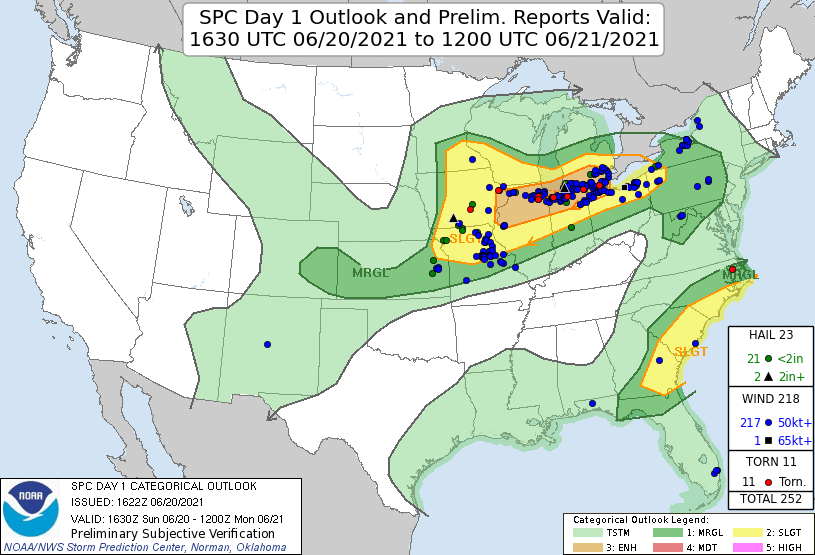
A strong tornado struck areas west of Chicago on Sunday night, June 20. A quick set of maps and data to remind myself about the event & what to talk about when it comes up in class.
Where
The general area where the tornado occurred is highlighted on this map, with other locales where there was rotation and/or damage shown too. The southwest suburbs tornado could end up being the first strong tornado (EF-2+) in the metro counties since 2015 (Coal City). #ILwx#INwxpic.twitter.com/FRyWobxh4j
The proximity sounding from KILX, with high CAPE, low LCL/LFC, and a very large 0-2 km hodograph but unidirectional winds above. All the convection-permitting models showed that this parameter space extended into N IL, to the convection itself (0-1 km SRH shown, but CAPE, other shear parameters, and therefore all the composite parameters demonstrated the same).
Nearest proximity sounding to last night’s Chicagoland QLCS tornado from KILX shows the types of environments out there last night pic.twitter.com/IGIZVyDxzz
The tornado occurred smack in the middle of the “enhanced” risk region. (As of the time this post was written, the tornado report was not yet included in the SPC database — but it should appear eventually.)
Storm
A very obvious debris signature just before 11:30 p.m. CDT. At first, I thought it odd that the velocity couplet wasn’t gate-to-gate — as it usually appears — but at this distance the radar is sampling at only 700-800 feet off the ground. That’s the tornado itself.
The storm lofted debris to nearly 20,000 feet (at least one image showed possible lofting a few thousand feed higher). Based on radar climatology, the strength of the rotational signature and height of the likely debris indicated a high probability of EF2 or EF3 damage.
It's never good to have to do these analyses this late at night, but the tornado that hit Woodridge, IL and nearby suburbs of Chicago was likely a strong EF3 based on an impressive 18,000+ ft TDS and a 66 kt Vrot, both remarkable for a QLCS tornado! #ilwxpic.twitter.com/ICdv3V15y4
A Naperville home is completely leveled to the ground. The damage was done to over 100 homes. 5 people were taken to the hospital with one that is in critical condition. Amazingly, no deaths to report. @WGNMorningNewspic.twitter.com/3SjW4V2TXS
A major flood event occurred in downtown Bloomington on June 18 and 19. Here are some photos and videos of the ongoing flooding, mostly near the Kirkwood Avenue and Campus Crescent area (I think that’s the correct name). I’ve also included a series of damage photos and the Indianapolis Star story from the morning of the 19th.
— Sarah Jones Breaks It Down (@SJBreaksItDown) June 19, 2021
was gonna go home last night but decided to wait, woke up this morning and there’s literally no way to get to my parents’ house – road’s blocked by downed trees and flooding every which way, apparently https://t.co/xGWoGJn2L2
A major flood event occurred in downtown Bloomington on June 18 and 19. Here’s an overview of just a couple pieces of the relevant meteorology.
Environment
A warm front lifted north through Indiana during the day, bringing dewpoints in excess of 70 F, and surface temperatures almost 10 F warmer than normal, even for June. The front would later stall and serve as the lifting mechanism for multiple rounds of storms.
Surface map from WPC, 19 UTC 18 June 2021
Deep atmospheric moisture, with precipitable water values that were 1-2 standard deviations above normal for June in Illinois and Indiana
The combination of extreme instability (see CAPE values in excess of 4000 J/kg, below) and a wind shear profile with only modest curvature (see the surface, 850 mb, and 500 mb wind “crossover” below) were favorable for multicell storms in the form of an MCS / squall line.
Radar loop to be inserted here later, but for now, here’s the 10 p.m. EDT radar image. These storms developed and moved almost parallel to Indiana Highway 46, between Terre Haute and Bloomington, for about three hours.
Precipitation Totals
From the CoCoRaHS network, consistent reports of 5 inches of rain, with one report in Ellettsville of 7.42 inches. At the Bloomington / Monroe County Airport, the report was 3.04 inches (I think), and the IU climate station reported 4.95 inches.
Climatology
This will be recorded as one of the largest rain events on record in Bloomington — looking at one-day totals, it ranks *fourth* on the all-time list.
(Given that more storms occurred this morning, and maybe more again later, we'll check two-day totals eventually.) #INwxpic.twitter.com/K6KXYvbSy2
Radar data have some correlation to tornado wind speeds:
The Jonesboro, AR tornado from a few minutes ago produced as TDS up to ~18,000 feet and a peak rotational velocity around 55 kt, placing it firmly in the EF3 range, which is also supported by analogous events. #arwxpic.twitter.com/NM27hZUal4
In the Plains, the dryline often serves as a focal point for convective initiation. It is quite rare to see a dryline propagate into Arkansas and Missouri:
The likelihood that many of our campuses will have to pivot, at least temporarily, to online learning for part of the spring semester is increasing. Here are the challenges I’m thinking about as I figure out ways to do this.
Synchronous or not? Do you expect all your students to “tune in” at the usual class time to attend an online lecture or discussion? Is it reasonable to expect that 100 percent of your students will be able to do this at the same time as your class usually meets? Does your university network have the bandwidth to accommodate every class on campus doing this? Do your students have fast home internet, or unlimited cell phone data plans, so that they can watch a high-quality stream for 1-2 hours multiple days per week? And, if any of these is a “no,” are you putting some of your students at a disadvantage? How will you accommodate them?
Content. So many issues about content. First: what content do you have, and how is it “performed?”
They can just read it. (easy to put online)
They can just observe it. (e.g., watch a video of a process or an action; easy to put online)
You need to demonstrate it. (maybe easy, maybe not, depending on what you’re doing: solving an equation, doing a lab demo, …)
They need to do it / practice it / demonstrate it. (really hard)
Content. What content cannot be delivered efficiently online? What do you do with that? Force it in anyway (“Here are some photographs of this fun activity you won’t get to do…”)? Jettison it? Something else?
Content. If you are recording videos, you absolutely must plan out every part of the lecture in advance. There is almost zero opportunity for the classroom spontaneity most of us love.
Activities. Do your normal class meetings have frequent group or team activities, where students discuss their ideas, compare their work, or work on problems together? How do you expect this to work in a setting where face-to-face communication is almost zero? (I’m thinking primarily of my own activities here, which are 2-, 3-, or 4-person, usually.
Grading. Are you ready to grade 100 email attachments?
Communication. How will students get to ask you questions about course content? Online lecture delivery, even if live, is normally quite passive, so there aren’t many opportunities for unprompted questions. If asynchronous, there are no chances like that at all, so all the questions have to be left on message boards or answered via email — so they could linger unanswered for hours.
Communication. Do you already have problems with students not following the instructions on your assignments? Or do you rely heavily on talking through assignments in class? Facial expressions, hand gestures, and inflection go a long way toward setting student expectations, and you won’t have that. How will you resolve this?
Communication. Do your students know your LMS as well as you do? Are they equipped with the knowledge they need to swiftly move from one page to the next, one assignment to the next, have multiple tabs open, etc.? (Don’t just assume that everyone aged 18-22 has the same skills as you.)
Delivery. Our attention spans (ages 18-80) are already short. For the love of all things holy, chunk your content into smaller pieces.
Delivery. This the media era. We are all trained on well-produced commercials, highly choreographed videos, and the like. A movie of slides projecting onto your kitchen wall, with muffled audio, will fail. Students will not watch, and they will go somewhere else to learn the content they need.
Delivery. Distractions are different when learning online compared to in the classroom. Some better, some worse. How does your lesson design consider this?
There are probably more, but these are the first few things I thought of while at dinner tonight. I’ll add more if I remember to.